
Slemma supports standard database table format. So most of the time your data will be just fine. If you have data that is made to be readable in a spreadsheet, make sure that your data are organized in raw table format arranged in columns, before you start manipulating the file you have.
Here you can download an example dataset.
NOTE: Fields in your table cannot be named “Measures”. You should rename it, otherwise you will not be able to save your dataset.
Titles
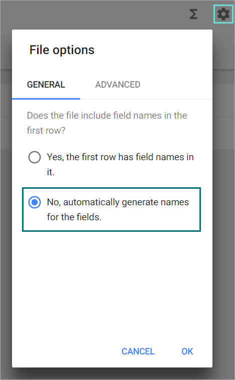
Titles should be in the first row. If you don’t have titles, that’s fine, just let Slemma know by going to the File options in the Dataset editor and switching to the No, automatically generate names for the fields option as shown below.
Columns and rows
Ensure that your titles are by columns instead of by rows. Each title of a measure or dimension should be in a separate column. If you have dates as column titles, please switch these to rows. Check out the example dataset above and you should get a good idea as to what it needs to look like.
Date and values format
At the moment we support the following date formats:
Years:
YYYY
Months:
YYYY MM
MM YYYY
month YYYY
MMM-YYYY (e.g. jan-2017)
Dates:
YYYY DD MM
MM DD YYYY
DD MM YYYY
MM DD YYYY hh
Possible separators:
.
–
/
space
For values:
- Avoid inserting currency symbols or percentages as you can set these formats in Slemma and it can complicate the upload process.
- Avoid total rows (in the middle or in the bottom of the table) calculated in Excel files before uploading.
Location and geospatial data
Slemma understands and can create maps out of data that contains states and countries. Specifically, the following location formats are supported:
- Country names (for example, England);
- Country codes (specifically, two-letter uppercase ISO-3166-1 alpha-2 codes) or their equivalent English name (for example, GB or United Kingdom);
- Region codes (specifically, uppercase ISO-3166-2 codes) or their equivalent English name (for example, US-NJ or New Jersey).
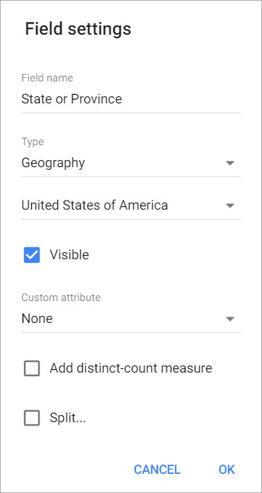
When importing the location data, be sure to choose the right map. We have a large range of maps available that you can choose from including a Google Map. For this, click on a column with geospatial data. In the appeared Field settings window, select Geography from the Type drop-down, and choose the appropriate map from the third drop-down. If you are interested in Google Maps go to this article.